
* Trail Maps & Self-guided Tours
Trail Maps:
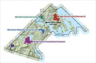
- Meredith Community Forest
- Hamlin/Eames/Smyth/Kahn
- Laverack Nature Trail at Hawkins Brook
- Page Pond/Sherman
- Swasey Park
- Waukewan Highlands
Self-guided Tours: These are interactive maps that you can view on a computer or a mobile device. Take it with you and it will guide you on your hike, locating points of interest along the way. You can even use GPS on your smart phone to see exactly where you are! Check back here as more guided tours will be added in the future.
- Hike to the White Mountain Ledge and Old Growth Trees in Hamlin/Eames/Smyth/Kahn
- Walk around the Quarry Loop and Leavitt Cemetery in Page Pond and Forest
- Yellow Trail to Crockett’s Ledge in Hamlin/Eames/Smyth/Kahn
- Winter Hike to the Beaver Pond in the Community Forest
- Hike to the Mill Dam in Page Pond and Forest
- Blue Trail around the Beaver Ponds in Hamlin/Eames/Smyth/Kahn
- Page Pond Field Loop and Bickford Homestead
If you notice any issues on the trails that need to be addressed, please let us know at: conservation@meredithnh.org
Trailhead Street Addresses (registered with emergency responders):
Page Pond Quarry Road Trailhead: 49 Quarry Road
Page Pond Barnard Ridge Road Trailhead: 88 Barnard Ridge Road
Page Pond Blueberry Road Hill Trailhead: 54 Blueberry Hill Road
Community Forest Trailhead: 42 Jenness Hill Road
Hamlin-Eames-Smyth Trailhead: 195 Chemung Road
Conservation Areas:
- Bear Island
- Carleton/Dockham
- Community Forest
- Hamlin/Eames/Smyth/Kahn
- Hermit Woods
- Jewell
- Leighton
- Long Ridge (Picnic Rock)
- Moulton Farm
- Nedeau/Edgerly
- Page Pond
- Piscopo
- Sherman
- Tucker Mountain
- Wood